What is a Watershed?
 A watershed, or drainage basin, is the total land area that is drained through a network of tributaries into a main waterway. A watershed, or drainage basin, is the total land area that is drained through a network of tributaries into a main waterway.
Turn the word watershed' backwards...shed water' sounds more like the meaning of this term: a watershed refers to the land area that sheds' its water into a body of water.
Water is always moving in a downward direction, so when precipitation falls to the ground, the water will either soak into the ground or flow across the surface toward the closest body of water as runoff. The lay of the land determines the direction water moves through and across the ground. Ridge lines, easy to identify on topographic maps, define the boundaries between watersheds.
Everywhere you go, you are in a watershed. Step into your backyard and consider the closest body of water to your home.
In Prince William County, most of our homes are close to a stream or pond. Water, the universal solvent, is the vehicle by which pollutants and garbage from our yards and streets travel to our waterways. The amount of surface water, and the accompanying pollutant loads, that runs off is determined by a variety of factors, such as climate, vegetation, topography, geology, land use and soil characteristics.
As the groundwater or surface water travels, pollutants and sediments attach to the water molecules. These pollutants also travel to the next closest body of water. Pollutants originating from a single source, such as a pipe, that you can point your finger' toward are referred to as point source pollution. point source pollution is regulated by federal, state and local laws.
Nonpoint source pollution refers to pollutants that come from a multitude of sources. Nationwide, nonpoint source pollution is the major contributor to water quality problems.
Nonpoint source pollution comes from a variety of human activities, including applications of fertilizers and pesticides, metals and oils from cars, household chemicals, erosion from construction sites and other land clearing activities, stormwater runoff from urban areas and sewage system overflow.
We all contribute to nonpoint source pollution. Often we don't understand how our activities affect local waterways. How we use and dispose of household or yard chemicals can make a difference. Although we may be small contributors individually, the cumulative impact from all residents in a watershed has a big effect. Everyone counts. And sometimes accidents happen. For example, one gallon of spilled motor oil can pollute up to two million gallons of water.
 Your watershed is made up of a network of connected waterways. Your watershed is made up of a network of connected waterways.
Watersheds come in a variety of shapes and sizes. Within the watershed boundary, the network of creeks and streams shows a branching pattern. This defines the path water and pollutants from your yard, or a parking lot, travel to larger creeks and even larger rivers.
Waterways that always flow, even during periods with little rain, are called perennial. Much of the water flowing in perennial streams comes from groundwater.
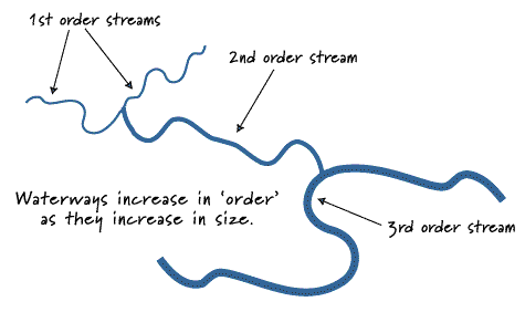
The smallest stream in the network is called a first order' stream. First order streams are located in the upper portions of a watershed, the headwaters. When two first order streams meet to form a larger waterway, this larger stream is called a second order' stream.
Water in the stream channel moves with a corkscrew-like pattern and at different rates of speed. The water close to the stream bottom is slowed by friction, while water close to the surface flows more quickly.
Where the stream curves, the faster flowing water at the surface pushes against the outer bank causing erosion of this area. The slower water near the bottom of the stream moves toward the inner bank, where it drops some of its sediments and silt. This simultaneous erosion of the outer bank and sedimentation at the inner bank results in the meandering shape we see in healthy creeks and rivers.
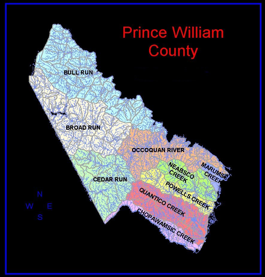
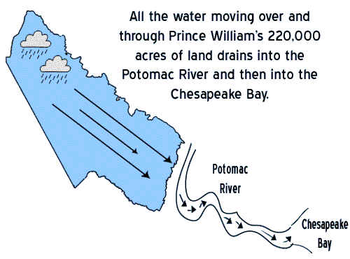
 There are ten major watersheds in Prince William County (see full-size map). All Prince William watersheds drain into the Potomac River. There are ten major watersheds in Prince William County (see full-size map). All Prince William watersheds drain into the Potomac River.
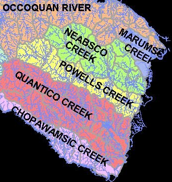
POWELL'S CREEK WATERSHED
Powell's Creek is a direct tributary to the Potomac River. The Powell's Creek watershed is about 18 square miles (11,520 acres). Originating near Independent Hill, Powell's Creek drains the Prince William landfill area, flows downstream to the Montclair community, where it is interrupted by Lake Montclair, and crosses I-95 just south of Cardinal Drive. Near the Potomac River shoreline, the southern boundary for the Powell's Creek watershed generally follows Cherry Hill Road down the Cherry Hill Peninsula.
Powell's Creek is an important natural resource. The wetlands of Powell's Creek stretch from west of Route 1 to the Potomac River. These wetlands protect the Potomac by filtering sediment and pollutants from the highways and residential developments now in the watershed. These wetlands also support the bass fisheries and waterfowl important to our emerging ecotourism industry.
The Powell's Creek watershed provides valuable habitat for many species, including migratory birds. As many as 35 species of warblers, 25 species of ducks, geese, and swans, 24 species of raptors, 15 species of sparrows and many other avian species use the estuarine area during migration and nesting. Bald eagles nest near the confluence of Powell's Creek and the Potomac River. Blue heron and osprey are common residents in this watershed. All of the mammal species native to Virginia's Piedmont may be found in the Powell's Creek watershed area. The Powell's Creek estuary is a "nursery" for aquatic organisms and makes a significant contribution to the health of the Potomac River and the Chesapeake Bay.
The Powell's Creek watershed (Potomac River/Quantico Creek/Chopawamsic watershed designation), has a Nonpoint Source Pollution Potential Ranking of "High." This creek has a Natural Heritage Watershed Priority Ranking of "High." In 1992 the Virginia Institute of Marine Science's study of tidal tributary streams along the Potomac River identified the Powell's Creek tidal wetland as one of the highest quality habitats of its kind in the Northern VA area. Click here to read more about the Powell's Creek watershed.
The Neabsco Creek watershed is located at the eastern end of Prince William County and feeds into the Potomac River. It covers about 27 square miles. Most of Dale City drains into Neabsco Creek. Development in the Neabsco watershed is extensive, varying from low density residential to high density commercial. Many of the wetland areas in the Neabsco Creek watershed have been developed. This, combined with the large amount of developed land, causes flooding problems in some parts of the watershed.
The EPA Office of Water has identified the Neabsco Creek watershed as an "area of significant habitat degradation due to a loss of natural land cover and storm water management facilities designed without consideration for environmental conditions." The loss of wildlife habitat, visually attractive streams and quality open space also degrades quality of life conditions for the people who live in the watershed. And because water quality conditions cannot support a diversity of life, recreation uses such as fishing are limited.
What happened to the Neabsco is unfortunate, especially because it was preventable. Now that the damage is done, repairs are expensive and will never restore Neabsco Creek to its natural beauty. Instead of forgetting about mistakes such as those made when the Neabsco watershed was developed, we should apply lessons learned.
For example, Powell's Creek, just south of Neabsco Creek on the Potomac, is now threatened with imminent medium and high density development. The Powell's Creek watershed is in danger of being developed in the same haphazard way as the Neabsco watershed. We need to remember what happened to the Neabsco and make sure that it doesn't happen to our remaining healthy, productive waterways. Prevention is more effective, environmentally and economically. Click here to read more about the Neabsco Creek watershed. |