The Proposed Manassas National Battlefield Park Bypass (Battlefield Bypass)
During a 2003 Prince William Smart Growth Forum, Dr. Steven Fuller, George Mason University, noted that although both I-95 and I-66 travel through Prince William, the lack of connectivity between major highways had allowed the county a unique opportunity to choose how it develops.
Theoretically, the main goal of the Battlefield Bypass is to remove remove Routes 29 and 234 from the middle of the battlefield and close the Battlefield to through traffic. However, the Battlefield Bypass Study will provide a final EIS that can be used by local, state and/or federal agencies to construct the segment of the north-south western transportation corridor that is on or abuts Manassas National Battlefield Park.
This road segment is the critical link in connecting the Route 234 bypass/Prince William Parkway to the Loudoun Parkway, thus completing the western transportation corridor. This major trucking and commuter route would connect I-95, I-66, Rte. 29 and Rte 50 (long-haul hazmat trucking routes) to Dulles Airport. Construction of a western transportation corridor that links major highways within Prince William County would dominate future land use choices and affect communities countywide. It's a big decision.
Purpose of the Study
The major goal of all build options is to remove Route 29 and 234 from the middle of the battlefield and close the battlefield to through traffic. The study is intended to focus on providing a four-lane thoroughfare for commuter traffic while increasing the quality of interpretative opportunities at Manassas National Battlefield Park. Theoretically, the final alternative should provide the greatest protection for the Battlefield and existing communities at the lowest cost.
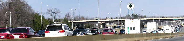
- The Civil War Preservation Trust has designated the battlefield as one of the Nation's ten most endangered battlefields because traffic congestion limits access to and corrupts historic interpretation of the battlefield. The alternative to the Bypass would be to widen Rte 29 within the Battlefield, likely to generate a national debate given the historical significance of this national park.
Underlying Assumptions and Impacts - All Proposed Alignments
- The Battlefield Bypass Study will provide a final EIS that can be used by local, state and/or federal agencies to construct the segment of the north-south western transportation corridor that is on or abuts Manassas National Battlefield Park. This western transportation corridor would be a major trucking and commuter route that connects I-95, I-66, Rte. 29 and Rte 50 (long-haul hazmat trucking routes) to Dulles Airport.
- The Study is providing the design for extending the Route 234 bypass from the intersection with I-66 to Route 234/Sudley Road at Sudley Park. This design will be used to construct a major north-south corridor that extends beyond Sudley Park into Loudoun County. The DEIS repeatedly asserts that this north-south corridor will be constructed before any Bypass project can be built. All build alternatives incorporate this north-south corridor in their design and the study assumes it would be built before the Battlefield Bypass.
- The Study assumes the Tri-County Parkway will be built.
- The Study treats construction of the Route 234 extension as merely a connection to Route 659 in Loudoun.
- The Study does not consider the significant vehicle trips that would be generated by connecting Prince William and Loudoun Parkways, creating a Western Transportation Corridor.
- The Study presumes that Groveton Road/Featherbed Lane remains open to through traffic.
- This would compromise interpretation of the Second Battle of Manassas.
- All proposed routes negatively impact existing communities along Pageland Lane.
- The Bypass Study has officially announced the preferred option is Alternative D, which relocates Route 29 to an area north of the Battlefield.
- Alternatives A, B, C also propose a northern route.
- Alternative G is the sole proposal for a southern route.
Proposed Northern Routes: Preferred Alternative D and Alternatives A, B, C
The northern routes would replace a two-lane road through rural areas with a major highway, significantly changing the character of existing communities and Manassas National Battlefield Park.
- Provides an alternate parallel north-south route through the Battlefield, negating the benefits of closing 234.
- Proposed routes are not free of traffic lights.
- Preferred Alternative D and Alternative B isolate existing communities between Sudley Park and Robin Drive , where homes currently directly access Route 234/Sudley Road.
- Intrudes into viewsheds, adds noise pollution and compromises historical interpretation of sensitive sites in the northern portion of the battlefield.
- Traverses Prince William's Rural Crescent and would spur development in outlying rural areas.
- Existing communities directly affected include Catharpin, Sudley Mountain Estates, Sudley Springs (Prince William) and Sunrise Hill (Fairfax).
Proposed Southern Route: Alternative G
The southern route would concentrate road improvements in already developed areas in Prince William and Fairfax, except for limited areas around Luckstone Quarry in Fairfax.
- I-66 and associated commercial development have already compromised the southern border of the Battlefield.
- Would benefit existing businesses.
- Makes no provision to allow traffic from the Route 234 bypass to directly access Rte 29 east.
- Existing communities affected include Bull Run Estates in Fairfax County.
What to Do
A Public Meeting is scheduled for May 5th at Battlefield High School from 6:30 to 9:30 PM. The Comment Period has been extended until June 6th.
SUBMIT YOUR COMMENTS to:
Mr. Jack VanDop
Federal Highway Administration
Eastern Federal Lands Highway Division
21400 Ridgetop Circle
Sterling , VA 20166
jack.j.vandop@fhwa.dot.gov
Support of local public officials will guide the decision process for the selection of the final alternative. All alternatives now negatively impact existing communities and advocating any one of these alignments is akin to stepping on a political third rail. Local officials need to hear community views.
At Large: Sean Connaughton, Chairman - sconnaughton@pwcgov.org
Brentsville: Wally Covington - wcovington@pwcgov.org
Coles: Marty Nohe - mnohe@pwcgov.org
Dumfries : Maureen Caddigan - mcaddigan@pwcgov.org
Gainesville : John Stirrup - jstirrup@pwcgov.org
Neabsco: John Jenkins - jjenkins@pwcgov.org
Occoquan: Corey Stewart - cstewart@pwcgov.org
Woodbridge : Hilda Barg - hbarg@pwcgov.org
|


