| |
The Impact of Southbridge Traffic on the I-95/Route 1 Corridor
A report by Protect Prince William, Ltd.
December 9, 2000
Executive Summary
The construction of Southbridge on the Cherry Hill peninsula will greatly increase
traffic in the Town of Dumfries and surrounding subdivisions and impact commuters
from Stafford County to Arlington who use the I-95/Route 1 transportation corridor.
These increases will occur despite the new road construction planned by Prince William
County and the Virginia Department of Transportation (VDOT), and despite the planned
Virginia Rail Express station at the Southbridge Town Center.
Since the Southbridge project was first proposed, the Legend Development
Company (the developer) has made a number of changes in density and types of homes to
accomodate traffic and other issues. A number of complex proffers have been made
regarding the phasing and pace of development. In the process, the traffic studies done by
the developer's subcontractor (Patton Harris Rust & Associates, PC) in December 1999
and subsequently by the County Planning Office staff have been modified to account for
these changes, so that the level of detail tends to obscure the numbers most relevant to the
public that will be most impacted, the Town of Dumfries and its surrounding
subdivisions. Also, with the exception of about a mile of Route 1, the developer's traffic
studies do not include the roads that are most congested at rush hour, the I-95/Route 1
corridor to Washington, D.C.
This report calculates average traffic volumes on the main roads near Dumfries
using the same methodology as the County Planning Office, with the most current
revisions to the Southbridge rezoning. By these calculations, the Southbridge
development and Town Center will add approximately 125,000 vehicles per day to Route
1 between Route 234 and Neabsco Mills Road. While some of these vehicles will
undoubtedly continue on Route 234, this represents an increase of between 20 and 40
percent in the congested I-95/Route 1 corridor.
Locally, Southbridge traffic will severely impact Possum Point, which will
experience at least a ten-fold increase in vehicles on Possum Point road. A number of
nearby subdivisions should expect longer commutes, including Hampstead Landing,
Wayside Village, Princeton Woods, Grayson Village, River Oaks, Fox Run Apartments,
Virginia Commons, Tripoli Heights, Georgetown Village, Anden at the Woods,
Washington Woods, Jefferson Woods, Chesapeake, Quantico Woods, Woodmark, River
Woods, Georgetown Village, and Village Gate.
The developer has not provided a detailed study of impacts. Given the level of
congestion on I-95 between Stafford County and Washington, D.C., such a study should
be undertaken before the County considers this development.
This report uses traffic data from the Staff Report on the Southbridge project, and
makes similar assumptions. Present traffic is based on traffic counts. Projected traffic
numbers are from the Prince William County Computer Code. Trip generation factors are
from the Policy Guide for Monetary Contributions, Prince William Planning Office (June
1, 1999).
This report uses County Planning Office Staff Reports for the Special Use Permit
Review #PLN2000-00077 (Southbridge Phase IIB-VII), #PLN2000-00078 (Southbridge
Phase IIA), and #PLN2000-00079 (Southbridge Town Center) to estimate type and
number of homes and commercial space at each phase of the project. These reports, dated
November 28, 2000, are the most recent available description of the project. However,
the proffers are complex and tied to various events outside of the developer's and the
County's control, such as the construction of an interchange at the intersection of Route 1
and Route 234. The developer may change the type and location of housing. This report
has made certain reasonable assumptions about the final character of the development.
Traffic Volumes
The Southbridge development will have a maximum of 2,900 dwelling units
(townhouses, apartments and single family homes), 2.4 million square feet of primary
employment uses (commercial and retail), and 1.3 million square feet of other non-residential uses. The developer is committed to a maximum of 350 townhouses and 316
age-restricted dwelling units of all types. For simplicity, we have divided the age-restricted units equally between townhouses and apartments.
The town center (#PLN2000-00079) will have 1,353 residential units, a mixture of
apartments, townhouses and single-family homes. Table ES-1 of the developer's Traffic
Impact Assessment and Transportation Plan anticipates 1,085 of these units will be
apartments, but this number is not a commitment. The town center will also have 992,000
square feet of non-residential development.
The two companion rezonings will have 1,235 dwelling units (#PLN2000-00077)
and 312 dwelling units (#PLN2000-00078), most of them single family homes, and the
remainder of the non-residential development.
The non-residential uses at Southbridge include 2.4 million square feet of primary
employment uses. The breakdown is roughly 50/50 between retail (a trip generation
factor of 44/1,000 square feet) and commercial (a factor of 10) in the town center. If this
assumption were carried throughout the development, it would imply roughly 1.9 million
square feet of retail-type applications (83,600 trips) and 1.8 million square feet of
commercial-type applications (18,000 trips).
Table 1 shows estimates of the traffic generation of Southbridge at build-out. The
final number (125,000 trips) is similar to traffic numbers arrived at by County staff and
the developer's consultants shown in Table 2.
Table 1. Traffic Volume Projections at Build-Out
| Type of Unit |
# of Units |
Factor |
Trips/day |
| Single family detached |
1,465 |
x 10 |
14,650 |
| Townhouses |
192 |
x 8 |
1,536 |
| Townhouses (age-restricted) |
158 |
x 5 |
790 |
| Apartments |
927 |
x 6 |
5,562 |
| Apartments (age-restricted) |
158 |
x 4 |
632 |
| Retail uses (in thousands of square feet) |
1,900 |
x 44 |
83,600 |
| Commercial uses (in thousands of square feet) |
1,800 |
x 10 |
18,000 |
| Total additional trips |
124,770 |
Table 2. Traffic Projections at Build-Out (from Traffic Study)
| Road |
Trips/day
(current) |
Trips/day
(projected) |
| Cherry Hill Road |
6,800 |
20,600 |
| Paper Mill Lane |
500 |
3,300 |
| Potomac Parkway (extension of Rt. 234) |
0 |
61,500 |
| Possum Point Road |
1,800 |
31,400 |
| Congressional Way |
0 |
22,800 |
| US Route 1 between Rt. 234 and Four Year Trail |
9,100 |
139,600 |
| Total additional trips |
130,500 |
The numbers in Table 2 were derived from the average daily traffic volume
comparisons at Southbridge's external intersections. The developer's subcontractor
limited the projections to traffic on Route 1 between 234 and Four Year Trail (the
entrance road leading to Potomac High School). The nearest actual intersection, however,
is Neabsco Mills Road, where the traffic will either turn onto I-95 or continue on Rt. 1.
The numbers in Table 1 and Table 2, arrived at by different methods, are in rough
agreement. They are also close to recent projections by Legend and the County staff.
Phasing
Southbridge will be built in four "development sequences," which the County
Planning Office has designated Development Sequence A (Applicant's Phase IIA, IIB, III
and VII); Development Sequence B (Applicant's Phase VI); Development Sequence C
(Applicant's Phase IV and V); and Development Sequence D (Build-out).
Using the same methodology as Table 1, Figure 1 shows the scale of traffic impact
at each phase on Route 1 between Route 234 and Neabsco Mills Road.
No Town Center
The developer's proffers make the construction of a town center conditional on the
construction of a new interchange at Route 1 and Route 234. If VDOT does not construct
this interchange, then the developer is under no obligation to construct a town center.
Table 3 shows the traffic impact at Route 1 between Route 234 and Neabsco Mills
Road if the town center is not constructed, using assumptions similar to Table 1.
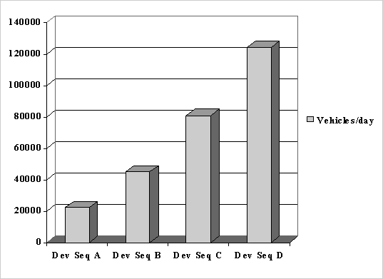
Figure 1. Additional Traffic on Route 1 at Each Development
Sequence
Table 3. Traffic Volume Projections at Build-Out (no Town Center)
| Type of Unit |
# of Units |
Factor |
Trips/day |
| Single family detached |
1,465 |
x 10 |
14,650 |
| Townhouses |
34 |
x 8 |
272 |
| Townhouses (age-restricted) |
316 |
x 5 |
1,580 |
| Retail uses (in thousands of square feet) |
1,500 |
x 44 |
66,000 |
| Commercial uses (in thousands of square feet) |
1,500 |
x 10 |
15,000 |
| Total additional trips |
97,502 |
Observations and Conclusions
The central fact of life for the Northern Virginia commuter is the daily traffic jam
on highways leading to Washington. This problem cannot be adequately addressed by
measuring levels of service at the intersections of a development the size of Southbridge.
More interchanges on Route 1 and I-95 will not change the fact that these roads simply
cannot accommodate existing traffic for the better part of the working day.
The Legend Development Company has not produced a traffic study that extends
more than a mile from their gates. The segment of Route 1 that will connect to Cherry
Hill Road and the Potomac Parkway is not heavily traveled at the present time. With the
planned widening to six lanes (if VDOT commits to this) may produce acceptable levels
of service at these intersections. However, there are no plans to widen Route 1 within the
town limits of Dumfries. This will create a bottleneck to the south. The bottlenecks to the
north are well known to Northern Virginia commuters. The developer's traffic study
dismisses these with a statement that some of the traffic will turn onto I-95.
Currently, the I-95/Route 1 corridor near Dumfries carries an average of 180,000+
vehicles a day. If even one fifth of the trips that spill onto Route 1from Southbridge use
the north-south route, it would increase the load over ten percent. Route 1 between Route
234 and Neabsco Mill Road will certainly experience five to ten times higher than at
present.
Possum Point Road is currently two lanes, and there are no plans to widen it.
Multiplying the current traffic on this road by ten or fifteen times will cause significant
commuting problems for the residents of Possum Point and the employees of the VEPCO
power plant.
A development the size of Southbridge will have long-term impacts on the
commuting pattern of Northern Virginia that cannot be adequately assessed by
examination of a few local intersections. Protect PW, Ltd. urges the County Planning
Commission and Board of Supervisors to require a much more detailed traffic study over
a broader area before considering Southbridge. |
|